Vloeiweide (ND)
LOCATION + COORDINATES
South of the city of Breda (NL), between the city of Breda and the Belgian border.
Floodplain restoration : 51.545025, 4.708832 decimal coordinates
CATEGORY
Demonstration sites for permanent natural water retention
Demonstration sites for temporary water retention
DESCRIPTION SITE
The site Vloeiweide is situated South of Breda within the catchment of the river Mark, along the tributary called "Bijloop". Historically, the rivers and brooks in the Mark valley have been strongly embanked. Normalized rivers are straightened and over-dimensioned in width and depth, by which they drain water excessively. During dry periods, low base flows and poor water quality are observed. This has strong implications for water provisioning. In the Markdal river basin the structure of the normalized brook "Bijloop" will be restored to a more natural state along a total trajectory of 1 km, by Waterschap Brabantse Delta (a Dutch water management authority) in collaboration with Brabants Landschap.
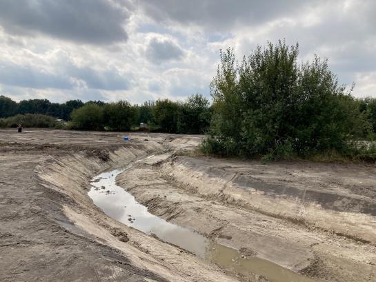
Through the addition of sand and woody debris, structure will be added to the water flow, causing it to meander at certain parts. A meander will be restored (see photo of the works below). Moreover the raised riverbeds will decrease drainage by the ‘Bijloop’. These EbA measures will allow water to flow at a slower pace through the landscape and increase water retention in the adjacent flood meadows as a result of the decreased drainage and increased groundwater level. The increased oxygen levels and microhabitats created in the stream and adjacent flood meadows will benefit biodiversity. A Dutch infographic about the demonstration site can be found here: https://www.brabantsedelta.nl/_flysystem/media/infographic-vloeiweide.p… .
MEASURES
Addition of sand and woody debris in the normalised brook
Raising the river beds of the normalised brook
Groundworks to restore wetlands in the floodmeadow adjacent to the brook

TIMING
2019 - 2022
BUDGET
€ 863 562
PARTNERS
Waterschap Brabantse Delta


