Scheppelijke Nete (BE)
LOCATION + COORDINATES
Gompeldijk, Mol (BE)
Floodplain restoration at 51.195402, 5.142085 decimal coordinates
CATEGORY
Demonstration sites for permanent natural water retention
DESCRIPTION SITE
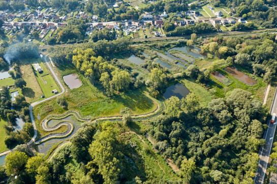
The investment site Scheppelijke Nete ("Gompels Broek") lies within the catchment of the river Nete, upstream the city of Mol. Several small rivers pass through the city of Mol. The fast discharge, resulting from upstream land use changes over the past decades, resulted in low groundwater levels during drought spells, as well as inundations in the city of Mol during intense rainfall. In the site 'Scheppelijke Nete', several recreational ponds were created (some used for commercial fish breeding) surrounded by dikes. As a result, a substantial part of the valley was excluded from water retention.
The Province of Antwerp bought about 8.3 ha of valley ground (most of them former ponds). Restoring the floodplain, including more natural ponds and a natural flood area, will increase the water retention and infiltration capacity of the area. In doing so, both intense rainfall and drought spells will be buffered.
In a first phase, the brook Burgemeesterloop was moved so that it no longer flows through the gardens and the risk of flooding in residential areas was eliminated. Then it was time for part two of the solution. A natural flooding area was created in the valley of the river Scheppelijke Nete upstream Mol city, thus creating extra buffer capacity for raw water. To this end, we removed exotics and pines, removed all constructions, naturalized the artificial fish ponds (removing the artificial embankment), and excavated the elevated areas and banks (due to placing the sediment on one riverbank). Water can now flow to the flood plain on both sites of the river. A specific management allows nature to restore spontaneous. The sediment catch, although artificially built, is a solution to prevent polluted sediment to enter the restored floodplain. Is uses the natural deposit of the sediment due to the fall in flow rate.
MEASURES
Removing mineral-rich and polluted topsoil, waste, cultivars, conifer trees, exotic species
Removing artificially raised dikes adjacent to the river and around the ponds
Building a walking trail/cycle path

TIMING
2019 - 2021
BUDGET
€ 308 420
PARTNERS
Provincie Antwerpen


